


Tilicho Lake sits at 4,919 metres (16,138 ft) in the Manang district of Nepal, tucked under the north face of Tilicho Peak inside the Annapurna Conservation Area. Most people reach it as a three-day side trip from Manang on the Annapurna Circuit, sleeping at Tilicho Base Camp (about 4,150 m) and walking up to the shore the next morning. You need no technical skills, but you do need good acclimatization, a careful pace on one exposed scree section, and a season when the trail is clear of snow.
That is the short answer. However, the rest of this guide covers what the walk actually feels like, how to fit it into your Annapurna plans, and the small decisions that make the difference between a great day at the lake and a miserable one.
Tilicho Lake at a glance
| Altitude | 4,919 m (16,138 ft) |
| Location | Manang district, Gandaki Province, Annapurna Conservation Area |
| Nearest village | Khangsar (3,734 m), about a day’s walk below base camp |
| Overnight stop | Tilicho Base Camp (around 4,150 m), teahouse lodges |
| Base camp to lake | About 770 m of climbing, 3 to 4 hours up and 2 hours down |
| Extra days needed | 3 days on top of a standard Annapurna Circuit |
| Best months | October, November, April and May |
| Permits | ACAP permit and TIMS card, with a licensed guide |
Where is Tilicho Lake, and what makes it special?
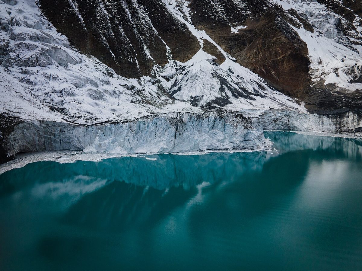
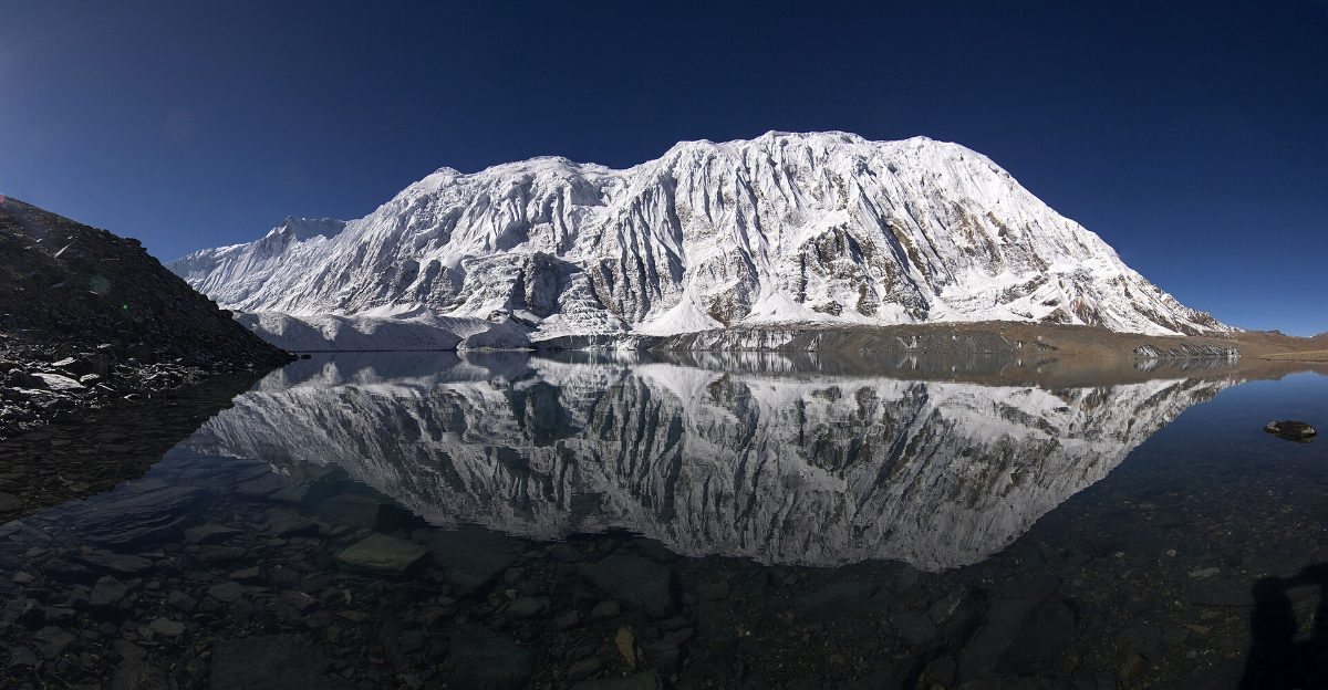
Tilicho Lake lies west of Manang village, at the head of a side valley drained by the Khangsar Khola, which eventually feeds the Marsyangdi River. To the south rises a long, ice-plastered wall running from Tilicho Peak (7,134 m) towards the Nilgiri peaks. Early French climbers called it the Grande Barrière, the Great Barrier, and once you stand at the shore you understand why. Its glaciers run right down to the water’s edge, and the fine glacial silt they feed in gives the lake its deep turquoise colour.
You will often hear Tilicho described as “the highest lake in the world.” That is not quite right. Several smaller lakes in the Andes and Tibet sit higher. What makes Tilicho unusual is the combination of size and altitude: it is roughly 4 km long and over a kilometre wide, which puts it among the highest lakes of its size anywhere.
The lake also has a quiet spiritual side. Many Hindus identify it with Kak Bhusundi Lake from the Ramayana, where the sage Kak Bhusundi is said to have narrated the epic in the form of a crow. Some pilgrims, many of them from India, make the long walk for that reason alone. Please treat the shore as a sacred site: no swimming, no litter, and no drones over people praying.
How to reach Tilicho Lake: the route, step by step
Firstly, there is no road to the lake and no shortcut. Everyone arrives on foot from Manang, so the first job is getting to Manang well acclimatized.
Kathmandu to Manang
The standard approach follows the Annapurna Circuit Trek. You drive from Kathmandu to Besisahar and on to Jagat or Dharapani, then walk up the Marsyangdi valley through Chame and Pisang. Jeeps now run all the way to Manang, so a few trekkers ride straight in. However, we do not recommend it for a Tilicho trip. Walking from Dharapani or Chame gives your body four or five days to adjust before you climb above 4,000 m, and that is exactly what you will need later.
Plan at least one full rest day in Manang (3,540 m). Use it well: hike up to the Chongkor viewpoint above Gangapurna Lake or to Praken Gompa on the hillside, then come back down to sleep. Climbing high and sleeping low is the best preparation you can give yourself for Tilicho.
Manang to Khangsar and Shree Kharka
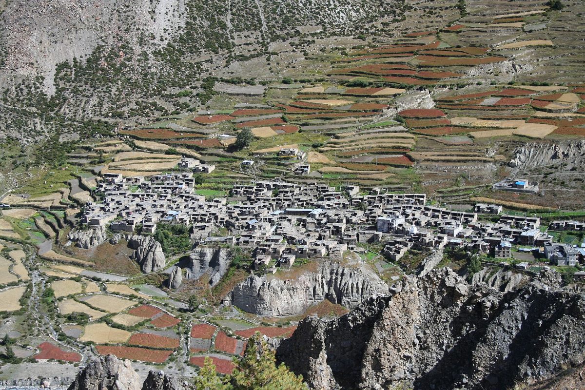
From Manang, the trail heads west across the river and climbs gently to Khangsar (3,734 m), a stone village with prayer walls and a small gompa. Beyond Khangsar, the path rises past an old monastery and onto open pasture, reaching the handful of lodges at Shree Kharka (about 4,060 m). Many groups therefore stop here for the night, which splits the climb into gentle stages. Others, meanwhile, push on to base camp in one long day.
Shree Kharka to Tilicho Base Camp: the landslide section
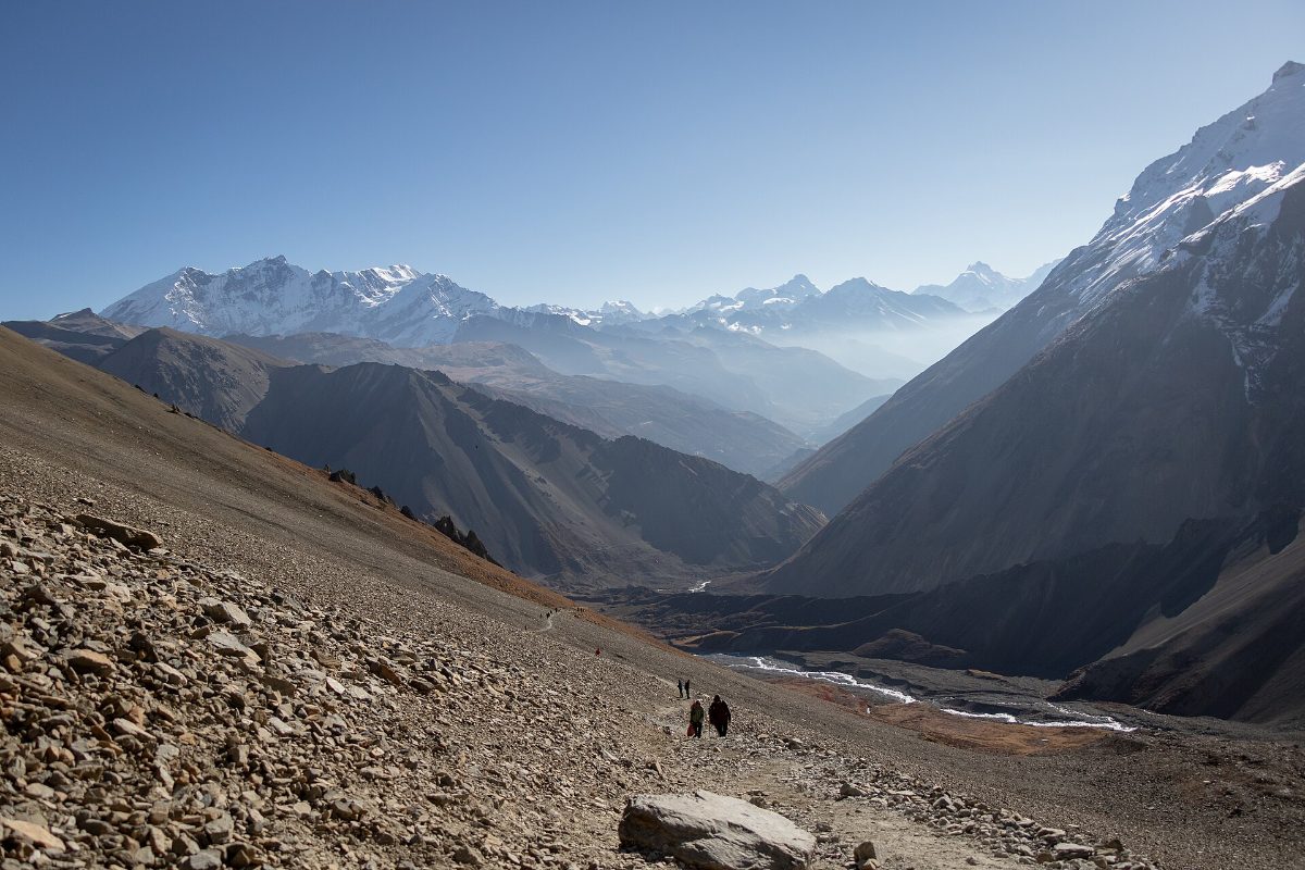
This is undoubtedly the stretch people talk about. For roughly an hour, the trail cuts across a steep slope of loose scree and eroded clay towers above the Khangsar Khola. The path itself is clear and wide enough to walk normally, but small stones can come down from above, especially once the afternoon wind picks up.
A few habits keep this section safe:
- Cross it in the morning, before the wind and the sun loosen the slope.
- Keep moving through the most exposed parts and save photo stops for the stable ground.
- Leave gaps between walkers so nobody knocks a rock onto the person below.
- Do not attempt it in fresh snow or heavy rain. Wait a day if you have to.
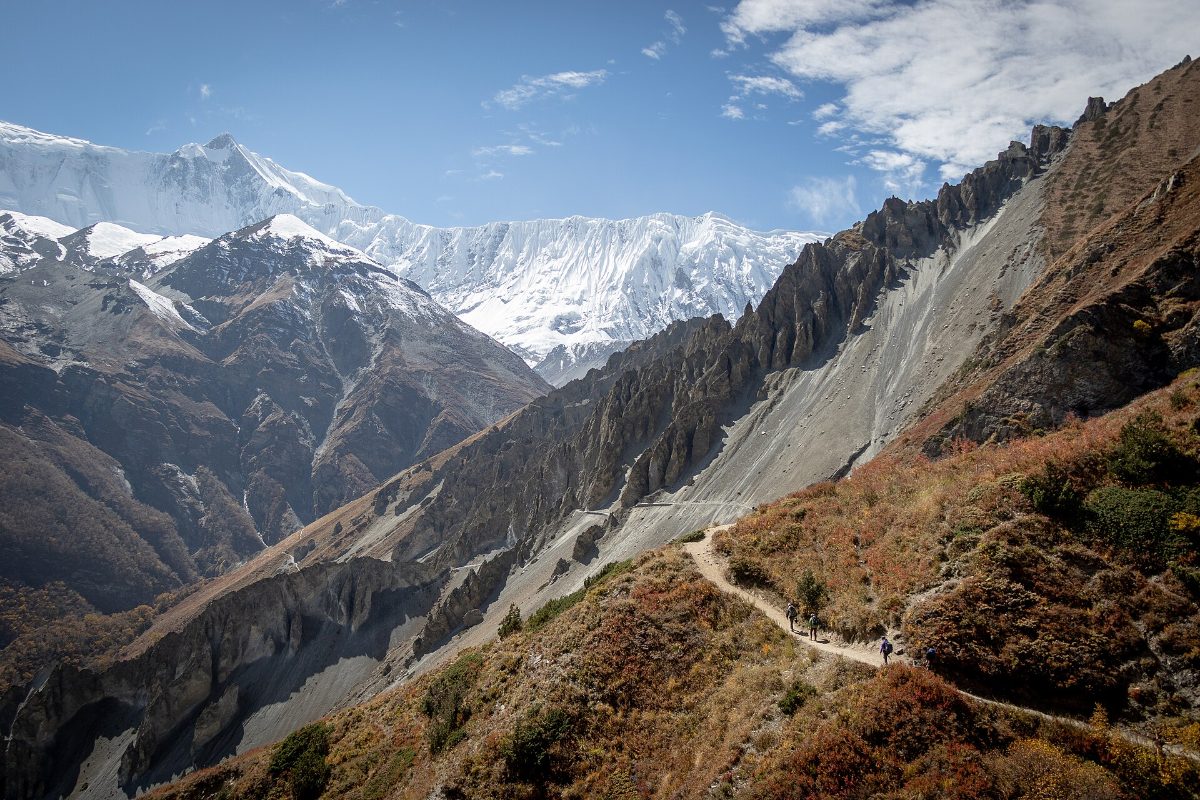
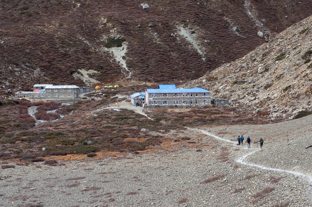
Afterwards, once you drop into the valley floor, the trail eases, and Tilicho Base Camp appears: a cluster of lodges with blue roofs sitting on a gravel flat at around 4,150 m.
Base camp to the lake and back
Summit day starts early, so expect to leave around 5 am with a headtorch. The trail zigzags up a long, steep moraine with roughly 770 m of height gain. It is not technical, but at this altitude every switchback counts, so go slowly and drink at every break.
After about three hours, the gradient softens, and you crest a broad shoulder. A teahouse shelter sits near the viewpoint in season, and then the lake opens up in front of you, framed by the glaciers of Tilicho Peak. On a calm morning, the reflection is almost perfect. By late morning the wind usually arrives, so aim to be at the shore between 8 and 10 am.
Finally, spend 30 to 45 minutes at the top, then head back to base camp for lunch. The descent takes around two hours and is hard on the knees, so trekking poles help a lot.
Leaving Tilicho: three ways out
- Back to Manang. The simplest option. In this case, you retrace your steps to Manang, then either drive down or continue up the main circuit.
- Across to Yak Kharka and over Thorong La. The most popular choice. From base camp, you return past Shree Kharka and then take a high trail across the hillside towards Yak Kharka, rejoining the main circuit without going back to Manang. You then go on to Thorong Phedi and cross the 5,416 m pass to Muktinath. Our Thorong La Pass crossing guide covers that day in detail.
- Over Mesokanto La to Jomsom. A remote, high route of around 5,100 m along the north side of the lake, finishing in Jomsom. It needs camping gear, a strong team, and current local information, and it is often impractical because of snow or access restrictions. We only consider it for experienced groups.
How many days do you need?
If you are already doing the Annapurna Circuit, Tilicho adds about three days. A typical side trip looks like this:
| Day | Route | Sleeping altitude |
| 1 | Manang to Khangsar and Shree Kharka | About 4,060 m |
| 2 | Shree Kharka to Tilicho Base Camp | About 4,150 m |
| 3 | Hike to Tilicho Lake (4,919 m) and back to base camp | About 4,150 m |
| 4 | Base camp to Yak Kharka (rejoin the circuit) | About 4,050 m |
Our 18-day Tilicho Lake Trek builds this into a full circuit, with a rest day in Manang, the lake, Thorong La, Muktinath and Jomsom, then a soak in the hot springs at Tatopani before you return to Pokhara. If you have extra time and like quiet trails, the neighbouring Nar Phu valley combines well with Tilicho too.
How difficult is the Tilicho Lake trek?
Overall, we grade it moderate to challenging. The walking is rarely technical, and most days are four to six hours long. The difficulty comes from three things:
- Altitude. You sleep at around 4,150 m two nights in a row and climb to almost 4,920 m. That is higher than the summit of Mont Blanc.
- The scree section. It demands attention more than fitness, and it is the part where conditions matter most.
- The steep climb to the lake. It is a long, sustained ascent on thin air, followed by a knee-jarring descent.
If you can walk six hours a day with a light pack and handle steep stairs without trouble, you are fit enough. In addition, a few months of hill walking, stair climbing and cardio will make the trek much more enjoyable. Our trek training plan works just as well for Tilicho. If you are still choosing between routes, this comparison of the Annapurna Circuit and Annapurna Base Camp may help.
Best time to visit Tilicho Lake
- October and November: The best window. Skies are clear, the trail is dry, and the lake is usually open water.
- April and May: The second-best season. Rhododendrons flower lower down the circuit, and the lake starts to thaw from late April, sometimes with floating ice.
- December to March: The lake freezes, snow can bury the scree section, and lodges at base camp may close.
- June to September: Manang sits in a rain shadow, so it stays drier than the rest of Nepal. Even so, rain loosens the landslide section, and clouds often hide the peaks.
For a wider view of conditions across the country, see our guide to the Nepal trekking seasons.
Altitude sickness and acclimatization
Tilicho is where many Annapurna trekkers first feel the altitude properly. Fortunately, the side trip also works as excellent acclimatization for Thorong La. Spending three nights above 4,000 m and touching 4,900 m before you go to Thorong Phedi makes the pass noticeably easier.
Keep these rules in mind:
- Take your rest day in Manang. Do not skip it to save time.
- Avoid gaining more than 500 m of sleeping altitude per day above 3,000 m where you can.
- Drink 3 to 4 litres of water a day and go easy on alcohol.
- A headache that does not ease with rest and water, vomiting, or confusion are signs to descend. Do not go up to the lake with symptoms.
Our full guide to altitude sickness explains the symptoms, medication, and how our guides handle it on the trail.
Permits and trekking rules
Tilicho Lake lies inside the Annapurna Conservation Area, so you need the same paperwork as the rest of the circuit:
- ACAP permit: NPR 3,000 for foreign nationals and NPR 1,000 for SAARC nationals, issued by the National Trust for Nature Conservation.
- TIMS card: NPR 2,000, issued through a registered trekking agency.
Since 2023, foreign trekkers in Nepal’s protected areas must walk with a licensed guide arranged through a registered agency. You show the permits at checkpoints in Dharapani, Manang, and sometimes Khangsar, so keep them in an easy-to-reach pocket. Our ACAP permit and TIMS guide explains how to apply and what to carry.
Lodges, food and costs on the Tilicho side trip
Accommodation in Khangsar, Shree Kharka and Tilicho Base Camp is simple teahouse style: twin rooms with thin mattresses and shared toilets, and a warm dining room built around a stove. Base camp can also fill up in October, so a guide who books ahead saves a lot of stress.
As a result, expect prices to climb along with the altitude. Everything above Manang arrives by mule or porter, so a plate of dal bhat or a pot of tea at base camp costs noticeably more than in Chame. There are no ATMs past Manang and card payments are rare, so carry enough Nepali rupees for the whole side trip. Our article on how much cash to carry on a Nepal trek gives realistic daily figures, and the Annapurna Circuit trek cost breakdown shows the bigger budget picture. Guided trips with Nepal Footprint start from US$2,400 per person for the full 18 days.
What to pack for Tilicho
Generally, your normal Annapurna kit covers most of it. A few items matter more here:
- A four-season sleeping bag rated to at least -10°C. Base camp rooms are unheated.
- A warm down jacket, gloves, and a hat for the dark start on summit morning.
- Trekking poles for the long descent from the lake.
- Sunglasses with good UV protection and high-factor sunscreen. Glare off the lake and glaciers is intense.
- A headtorch with spare batteries, plus snacks for the climb.
- Microspikes from November onwards, in case of ice on the upper trail.
The full checklist is in our Nepal trekking equipment guide.
Is Tilicho Lake worth the extra days?
For most people, the answer is yes. The main Annapurna Circuit is a wonderful walk, but it has become busier since the road reached Manang. The Tilicho Valley still feels wild. You get a huge glacial lake, a wall of ice towering 2,000 m above it, and quiet evenings at base camp with blue sheep grazing on the slopes. Besides, you arrive at Thorong La better acclimatized.
It may not suit you if you are short on time, struggle with heights on narrow paths, or are trekking in deep winter. In those cases, a rest day hike from Manang to Ice Lake (Kicho Tal) gives a taste of high-altitude scenery without the extra days.
Plan your Tilicho Lake trip with a local team
Our guides walk the Manang valley every season and know when the scree section is safe, which base camp lodges are open, and how to pace the climb so you reach the shore while the water is still calm. Have a look at our Tilicho Lake Trek itinerary, or contact our team to build Tilicho into your own Annapurna dates.
Frequently asked questions about Tilicho Lake
How high is Tilicho Lake?
Tilicho Lake is at 4,919 metres (16,138 ft) above sea level, in the Manang district of the Annapurna region.
Is Tilicho the highest lake in the world?
No. Some smaller lakes in South America and Tibet are higher. Tilicho is better described as one of the highest lakes of its size in the world.
Can I visit Tilicho Lake without doing the Annapurna Circuit?
Yes. You can drive to Manang, acclimatize for two nights, then walk to the lake and back in three to four days. Because a fast drive gives you little time to adjust, we still suggest walking at least part of the valley.
Is the trail to Tilicho Lake dangerous?
It is safe in good conditions with a sensible plan. The main risk is rockfall on the scree section between Shree Kharka and base camp. Cross it in the morning and avoid it after fresh snow or heavy rain.
Can you swim in Tilicho Lake?
No. The water is close to freezing, the altitude makes cold shock dangerous, and many visitors consider the lake sacred.
Do I need a guide for Tilicho Lake?
Yes. Under current rules, foreign trekkers in the Annapurna Conservation Area must trek with a licensed guide arranged through a registered agency. A good guide also knows the trail conditions on the landslide section from day to day.